Warning
Please note that the documentation you are currently viewing is for an older version of our technology. While it is still functional, we recommend upgrading to our latest and more efficient option to take advantage of all the improvements we’ve made.
Retrieve Geographic Data with Google Maps API
In this article, we will learn how to use the HTTP Library to obtain distance data from a Google Maps API.
Let’s say we’re planning a road trip in Europe and we want to visit sites in different cities. We can use the Distance Matrix API from Google Maps to calculate important information for our trip.
We want to know:
Distances between locations
Travel time from one location to another
Prerequisites
Before we begin, there are a couple things you’ll need to have in place.
Install the HTTP library, please read Adding the HTTP Client Library
Get a Google API key. Get one from Google Maps Platform: Get an API Key
API Requirements
We need information about the authentication required and the request format. As indicated in Google Maps Developer Guide: Required Parameters, these are required parameters for the request:
origins— The starting point for calculating travel distance and time. You can supply one or more locations separated by the pipe character (|), in the form of an address, latitude/longitude coordinates, or a place ID.destinations— One or more locations to use as the finishing point for calculating travel distance and time. The options for the destinations parameter are the same as for the origins parameter, described above.key— Your application’s API key. This key identifies your application for purposes of quota management.
Specify these parameters by putting them at the end of the request URL:
As indicated in Google Maps Developer Guide: Distance Matrix Requests the format should look like this:
Note that while the Google Maps API supports both JSON and XML outputs, AIMMS only supports XML, so outputFormat will be xml.
With the mandatory parameters, the URL would look like this:
https://maps.googleapis.com/maps/api/distancematrix/xml?destinations=DESTINATIONS&key=KEY&origins=ORIGINS
The API contains plenty of other optional parameters, such as the distance unit or the method to calculate travel duration. Learn about the available options for your request in the Google Maps Developer Guide.
Example Project
You need to complete two steps to be able to use the distance data retrieved from the API in your AIMMS model.
Create a request to the API to get an XML response file
Import the data from the XML file to your AIMMS identifiers
You can download the example AIMMS project here:
Creating the Request
Lines 1 through 15 in the procedure GetDistances represent an example request to the API. You must replace the “YOUR_API_KEY” in Line 1 with your Google API key from Prerequisites.
 1APIkey := "YOUR_API_KEY";
 2responseFile:="Output.xml";
 3ListOrigins:="Eiff Tower, Paris | The atomium is in Brussels | AIMMS Haarlem | Roma Italy Coliseum | The alhambra, granada spain";
 4ListDestinations:="Eiffel Tower, Pari | The atomium, Brussels | AIMMS Haarlem | Coliseum, Roma Italy | The alhambra, granada spain";
 5!Set the values for the parameters we want to use
 6requestparameters := { 'key': APIkey, 'origins': ListOrigins, 'destinations' : ListDestinations };
 7!Set the request
 8web::query_format(requestparameters,formattedparameters);
 9URL:="https://maps.googleapis.com/maps/api/distancematrix/xml?"+formattedparameters;
10!Create and submit the request
11web::request_create(requestId);
12web::request_setMethod(requestId,"GET");
13web::request_setURL(requestId,URL);
14web::request_setResponseBody(requestId,'File',responseFile);
15web::request_invoke(requestId,responsecode);
Most of this code is common for every HTTP request sent using the HTTP Client Library, and will not be reviewed in this article. Read more about how to formulate an HTTP request in AIMMS in Extract XML File from a Server with the HTTP Library.
GetDistances has the below locally declared identifiers.
Set TotalParameters {
    Index: tp;
    InitialData: {
        DATA{origins,destinations,address,key,mode,language,region,avoid,units,arrival_time,departure_time,traffic_model,transit_mode,transit_routing_preference};
    }
}
StringParameter requestId {

}
StringParameter requestparameters {
    IndexDomain: tp;
}
Parameter responsecode {

}
StringParameter APIkey {

}
StringParameter ListOrigins {

}
StringParameter URL {

}
StringParameter responseFile{

}
StringParameter formattedparameters {

}
The set TotalParameters contains all possible parameters available for the API, required or optional.
Following the API documentation, we create two strings storing the different origins and destinations separated by “|” characters in Lines 3 and 4. The choice to use location names instead of coordinates is arbitrary. We want the total distance matrix between locations, so each location is in ListOrigins and ListDestinations.
1!Set the Locations
2ListOrigins:="**Eiff** Tower, Paris | The atomium is in Brussels | AIMMS Haarlem | Roma Italy Coliseum | The alhambra, granada spain";
3ListDestinations:="Eiffel Tower, **Pari** | The atomium, Brussels | AIMMS Haarlem | Coliseum, Roma Italy | The alhambra, granada spain";
Tip
There is no need to be meticulous in these location definitions. Purposely, we’ve included some errors and format variations in the location names to illustrate that Google Maps can guess the corrections needed in most cases.
Important
The API has tiers of billing plans with various usage limits. See Google Maps Developer Guide: Usage and Billing.
We specify which parameters to use in requestparameters and assign them values in Line 6. Here, we only specify the required parameters, but you can add optional parameters in the same way.
1!Set the values for the parameters we want to use
2requestparameters := { 'key': APIkey, 'origins': ListOrigins, 'destinations' : ListDestinations };
Now that we have set up our parameters, we will translate them into a URL using the web::query_format method and to put the resulting string formattedparameters at the end of our URL in Lines 7 to 9.
1!Set the request
2web::query_format(requestparameters,formattedparameters);
3URL:="https://maps.googleapis.com/maps/api/distancematrix/xml?"+formattedparameters;
Once this URL is generated, you just need to create a GET request and submit it to the API. This is done in lines 10 through 15.
1!Create and submit the request
2web::request_create(requestId);
3web::request_setMethod(requestId,"GET");
4web::request_setURL(requestId,URL);
5web::request_setResponseBody(requestId,'File',responseFile);
6web::request_invoke(requestId,responsecode);
Executing this code will download the response XML file in the root folder of your project, or any other location as specified in responseFile.
Mapping the Data
Now we have access to the XML response file. We need to map the data from this XML file into AIMMS using the XML schema mapping tool. By taking a look at the XML file, we can identify the important data to export in AIMMS.
The origin_address and destination_address are elements that contain the exact locations guessed by Google using your request location strings. For each travel, there is a duration and a distance folder containing value and text elements. The value contains the duration (or distance) as a number while the text contains it as a string.
Now that we know what we want from the XML file, we will need an XSD file. This XSD file provides the structure for an XML file. Read more about XML Mapping and creating XSD files in Extract Data from an XML File.
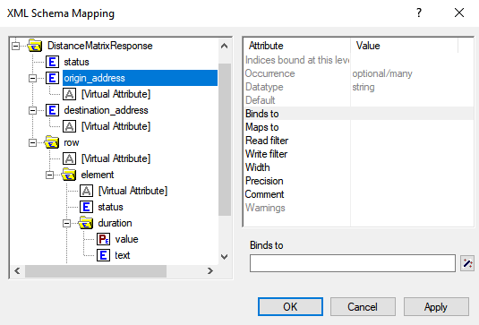
When you select an element, the mapping tool gives you access to a list of attributes.
binds-to: links an index with an element having an attributeoccurrenceequals to “once”, and that is not in the root node. It also links the parent node from the bound element and any child elements to the index, so their data can be used as parameters of the index based on theirmaps-toattribute.maps-to: links an element’s value to an AIMMS identifier (e.g., sets, parameters).
Here, we can’t bind the elements origin_address or destination_address to a set because their occurrence attribute equals “optional/many” and their position in the root node. Meanwhile, if we bind an index to the status element from the Element folder, we would not be able to map the origin_address to a parameter of this index.
Therefore, we cannot use origin_address and destination_address as indices to have parameters Distance(origin_address, destination_address) and Duration(origin_address, destination_address) with this XML file.
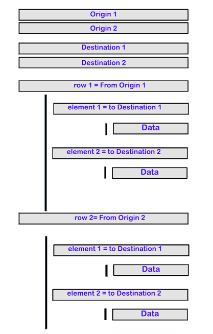
Instead, we will use virtual attributes. These attributes aren’t part of the XML file but can be simulated. The virtual attributes are an enumeration of contents of the root element. For example, the second element in destination_address will have a virtual attribute value of 2 and the third element will have a value 3. Thus, 2 will become the ID for the 2nd destination_address: “The atomium”.
Given the structure of the XML, the virtual attribute for row will also correspond to the origin ID for the travel and the virtual attribute for element will correspond to the travel destination ID.
Here is an example schema for the XML:
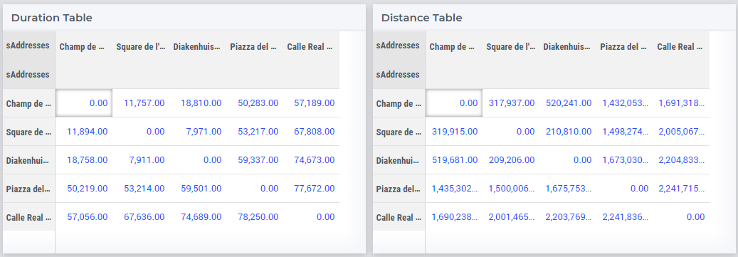
As we are creating a distance (time) matrix for the given set of locations, we will use a set sAddresses with two indices - iOrigin and iDestination. Then, origin_address and destination_address will be string parameters indexed over this set. The elements in sAddresses will be numbers 1, 2, and the values of origin_address and destination_address will be the corresponding addresses.
Declare the below identifiers in your project:
Set sAddresses {
   Index: iOrigin, iDestination;
}

StringParameter spOrigin {
   IndexDomain: iOrigin;
}

StringParameter spDestination {
   IndexDomain: iDestination;
}

Parameter pDuration {
   IndexDomain: (iOrigin, iDestination);
}

Parameter pDistance {
   IndexDomain: (iOrigin, iDestination);
}
Using the XML Mapping Tool, create the following mapping:
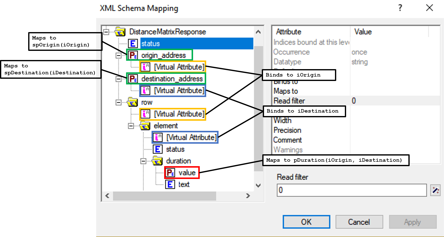
origin_addressvirtual attribute binds toiOrigindestination_addressvirtual attribute binds toiDestinationrowvirtual attribute binds toiOriginelementvirtual attribute binds toiDestinationDuration/valuemaps topTime(iOrigin, iDestination)Distance/valuemaps topDistance(iOrigin, iDestination)origin_addressmaps tospOrigin(iOrigin)destination_addressmaps tospDestination(iDestination)
Important
Don’t forget to set the attribute Read-filter to 0 for every unused element or parameter in the mapping (two each of status and text elements) . The Read-filter attribute is accessible by selecting the element or parameter.
Now, you just have to read the XML file data.
READXML(responseFile,"YOUR_XSD_FILE_NAME.axm");
You can use spOrigin or spDestination as the webui::ElementTextIdentifier for the set sAddresses to get the final tables as below.